


DO YOU WANT TO GET SOMETHING FREE?
Tuesday, May 19, 2020This blog will help readers find information about a piece of property by using the WILL COUNTY SUPERVISOR OF ASSESSMENTS PAGE on the internet: http://www.willcountysoa.com/search_pin.aspx
Typing in this web address will bring you to a page like EXHIBIT A.
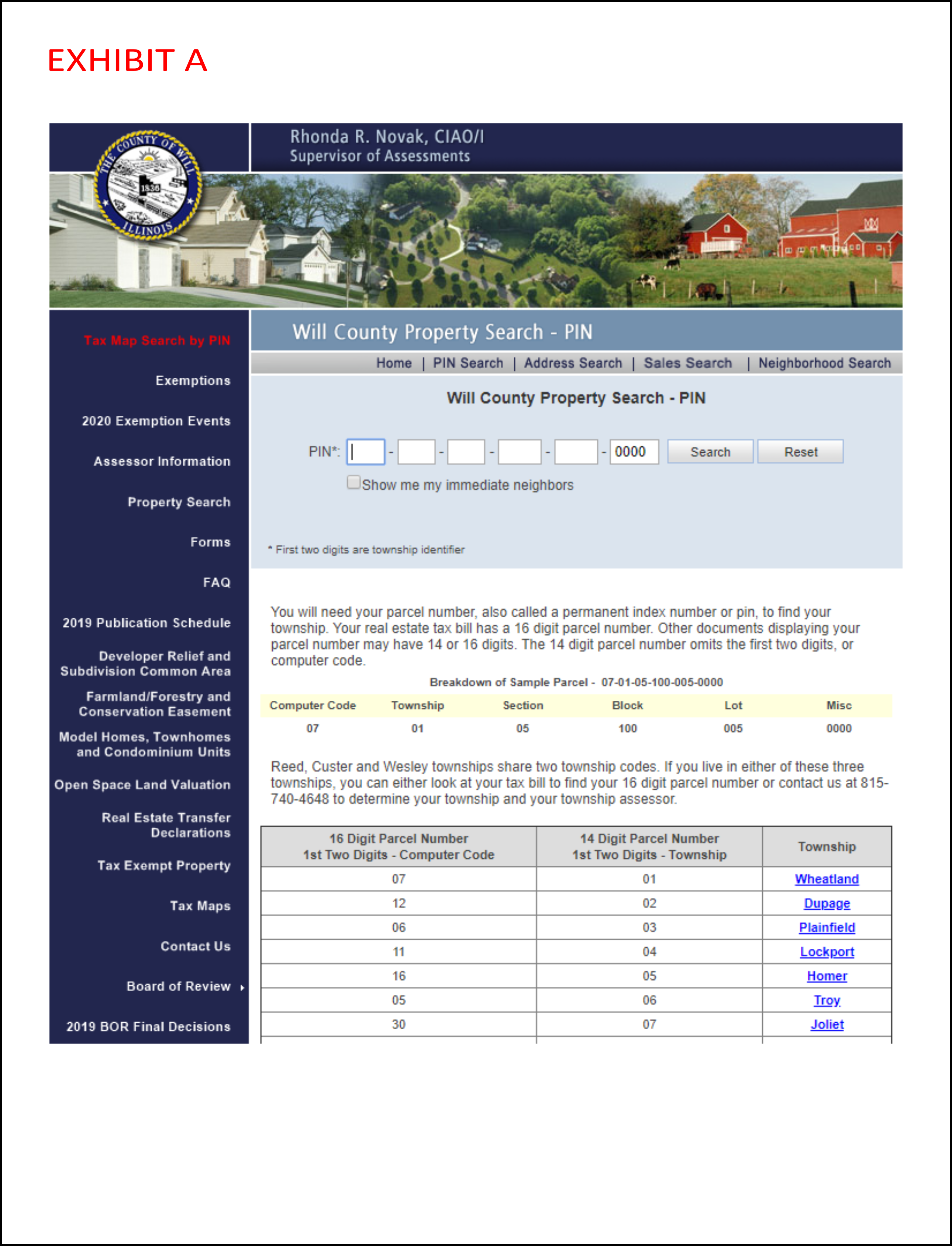
- How to obtain a tax parcel number (PIN) or using your own property PIN.
- Click on TAX MAPS – dark blue side bar to the left, halfway down.
- On the next page, scroll down to the line in red that says CLICK HERE FOR TAX MAPS and click.
- You will then see a screen that shows you all 36 townships in Will County.
- Choose Joliet and you will see a map of Joliet Township.
- Search until you find the area of interest, using the arrow on the left side of the second bar to move between screens.
- For this example, pick the white box in section 1, just east of Briggs Street and north of Maple Road. You can then print a copy of the tax map for Joliet Township, the West half of the Southwest quarter of Section 1, in Township 35 North, Range 10 East – the printout shows you this information in the upper left corner of Exhibit B.
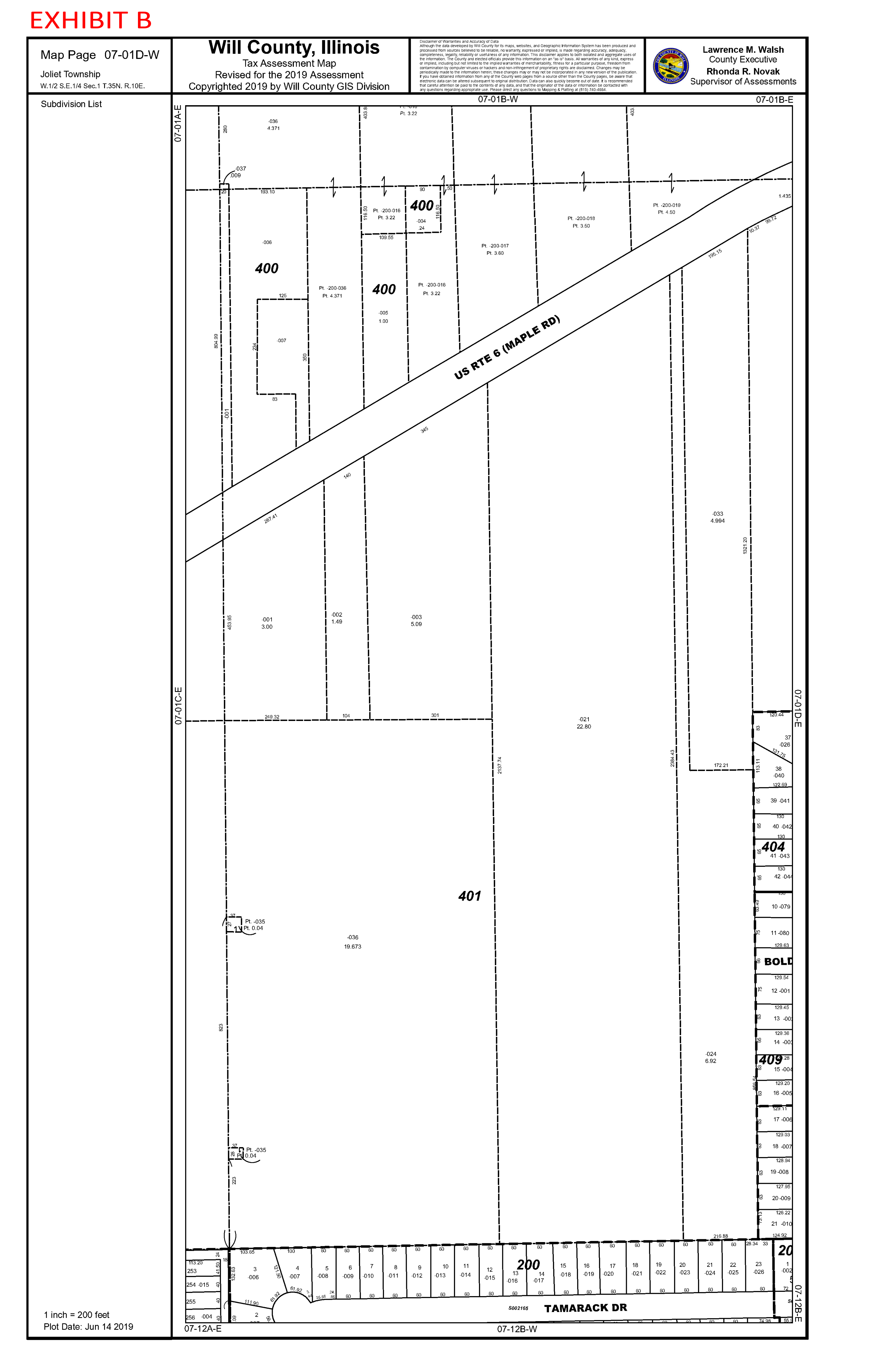
- You need to know that the code number for Joliet Township is 30. This is the first part of five-part number that defines the PIN. The exhibit has an arrow to the Lot we are looking at for this example.
- The second and third numbers can also be found in the upper left-hand corner of Exhibit B. We then have 30-07-01.
- The next number we need is the block number, shown as a bold black number which, in this case, is 306.
- Now we have 30-07-01-306.
- We then need to find the code for lot 117. This number is found just above the and to the right of the block number 306, in this case, it is -010.
- We now have the completed tax parcel number, 30-07-01-306-010.
- This PIN will enable us to continue our research on EXHIBIT A.
- By using the tab in the top bar labelled 19_07-01cw.pdf we can return to EXHIBIT A.
- Click the black X in the tab to return.
- By selecting the PIN SEARCH BAR IN GREY http://www.willcountysoa.com/search_pin.aspx
- with a square surrounding it on EXHIBIT A.
- We can now type in the tax parcel number 30-07-01-306-010. This search will now take you to EXHIBIT C.
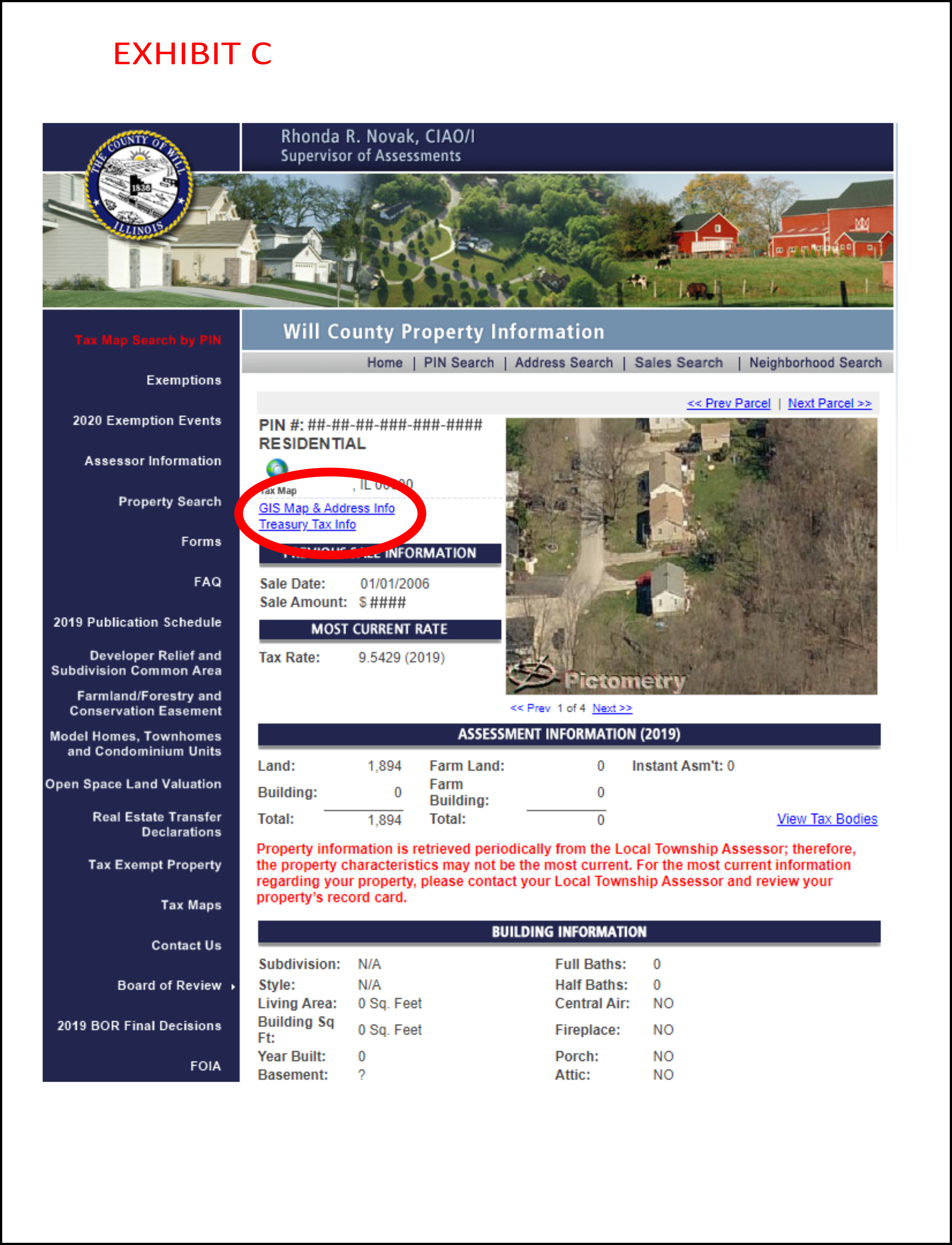
- This page will show you many types of information.
- tax parcel number,
- residential lot,
- GIS MAP & ADDRESS INFO
- TREASURY TAX INFO
- PREVIOUS SALE INFORMATION (2006 in our example) and the sales amount
- MOST CURRENT RATE (2018)
- ASSESSMENT INFORMATION (2019)
- BUILDING INFORMATION
- short abbreviated legal description: LOT 117 IN THE MAPLEBORO SUBDIVISION, BEING PART OF THE WEST HALF OF THE SOUTHWEST QUARTER OF SECTION 1, IN TOWNSHIP 35 NORTH, RANGE 10 EAST OF THE THIRD PRINCIPAL MERIDIAN, IN WILL COUNTY, ILLINOIS.
- This page will show you many types of information.
- Let’s return to the TREASURY TAX INFORMATION TAB ON EXHIBIT D. This will show you:
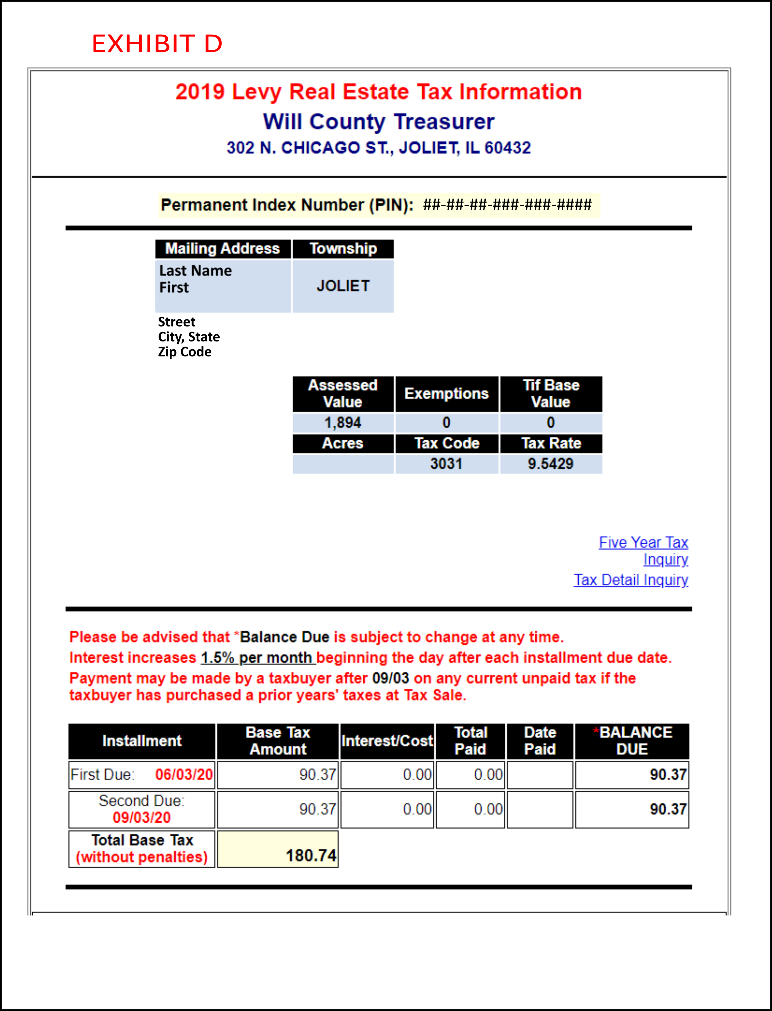
- who is paying the taxes and where they live
- assessed value
- tax code
- tax rate
- A little lower on the page is the taxes due on the property and when they are due.
- To return to EXHIBIT C, close the tab marked INQUIRE REAL ESTATE TAX INFOR, you will then return to EXHIBIT C.
- We then want to pick the GIS MAP & AND ADDRESS INFORMATION. This will take you into the WILL COUNTY GIS DATA VIEWER. The opening page is shown as EXHIBIT E. This is a split screen that shows:
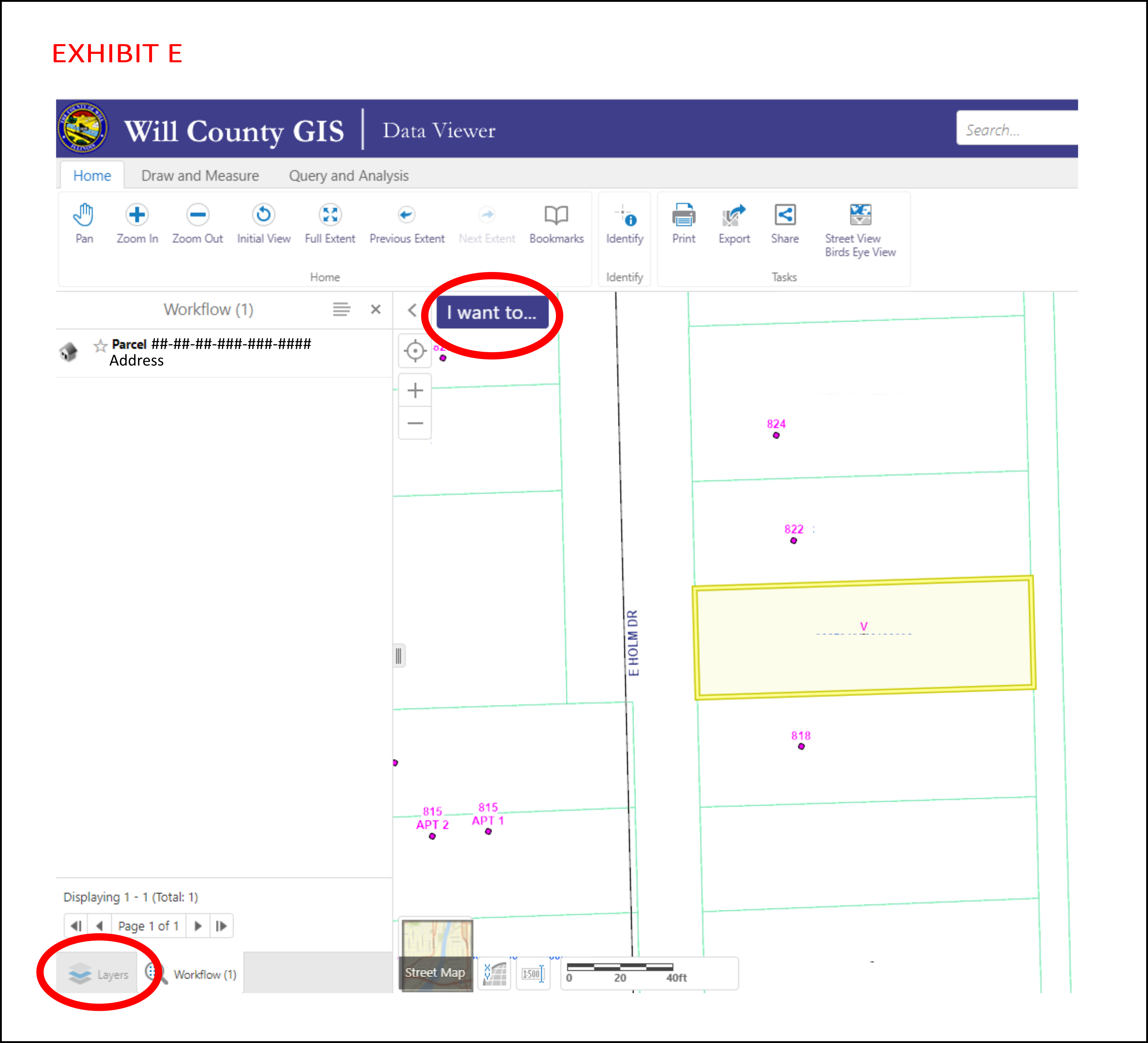
- the lot you are interested in,
- its tax parcel number.
- It is located on the right hand side; it has the lot tinted yellow and a darker yellow line around it. The parcel numbers are show on each side of it, and it shows the addresses for each side.
- If it shows an address it means, there is a building on it.
- If you look on the left hand side of the screen, in the lower left hand corner there is a box called layers. Pick the layers box.
- The standard layers have a check mark in front of it, you can add information by checking additional layers.
- The first box checked is address and property parcels, roadways and parcels are checked, by picking buildings they show up, the same with water features they show up, by picking tax maps and lot dimensions they appear.
- Moving down to elevations contour and checking it two foot contours appear.
- Moving down again when you pick aerial photos and check 2019 – 6 inch Aerial Photos of the area surrounding the lot. You can zoom in or out to enlarge or reduce the drawing by using you mouse.
- The next pick you want to make is the blue I WANT TO BOX. There are various options for setting up your drawing.
- You can set you paper size, PDF output, resolution, grid, map scale, title and notes.
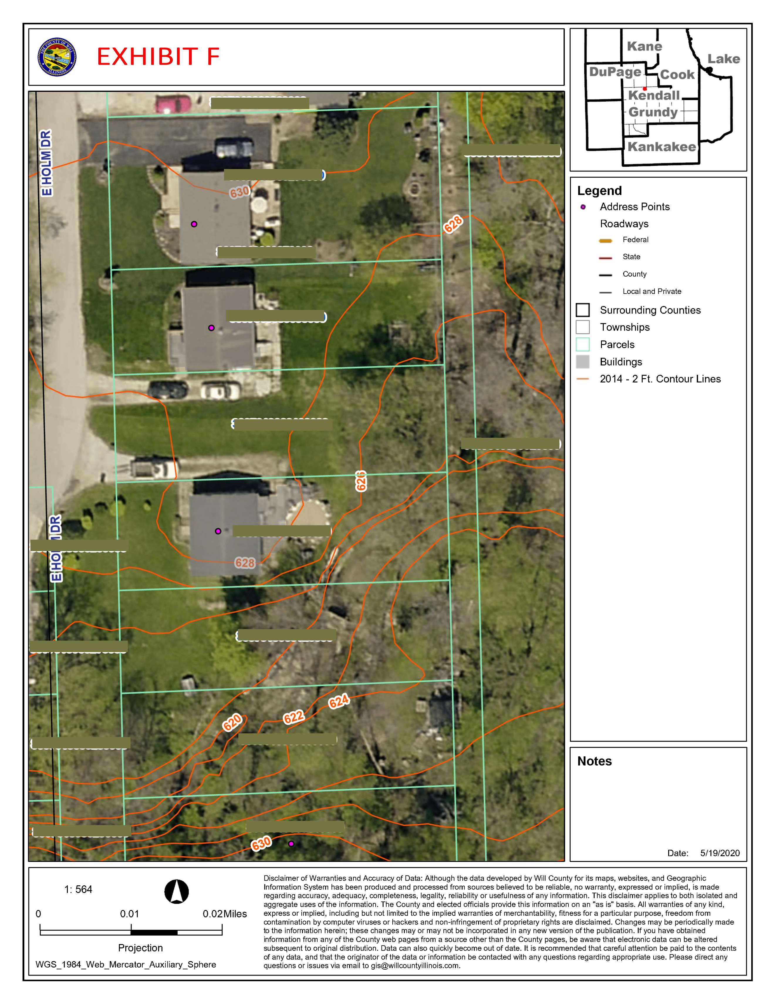
- You then need to pick the print box in the lower right hand corner or the left side. The file will be prepared, when the open file comes up pick it. By moving your mouse to the top of the page a black pick box will come up, pick it and it will configure your drawing getting ready to print. Youi must have a color printer to receive the drawing in color. You can control the paper size, by printing the blue, print button you will get a drawing that looks like EXHIBIT F.
Try doing the drawing using your tax parcel number in will County. Many other counties in many other states have similar systems.
Thank you for reading,

Lee R. Koehler, PLS