Ask an Engineer Why and How, Installment 5: What Is A 100-Year Flood?
Monday, April 29, 2019
“It seems like there is a 100-year flood somewhere, EVERY year. Something must be changing!”
This topic can get me on a soap box because people do not seem to understand how short our lives are, and experience is, in relationship to the life of our earth. Something IS changing. We’re collecting more data.
Right now, we have reasonably accurate hydrologic data in Illinois for about 125 years. We take that data, analyze it, and determine what precipitation event has a 1 in 100 (1%) chance of occurring in a year. Once we have estimated the rainfall event by using statistical analysis, we then predict that it will occur uniformly over the entire drainage area (watershed) of a stream or river and we use software programs to estimate how much flow will be produced in the stream and how high the water will “flood” from that flow. That’s how we develop the “100-year” flood elevation.
When I was in college we did this with paper maps, calculators, and nomographs – but we were starting to write computer programs to perform the calculations. One of my graduate research projects was tedious program writing in Fortran for a hydraulic model to be used by the Tennessee Valley Authority (TVA). Today I could do a lot of that work with a spreadsheet – but my TVA work was beyond cutting-edge at the time. My older brother used a slide rule for similar work as did my father, but I’m off topic again…
The mathematical fact is that this approach can be fairly accurate (related to the estimated rainfall) for smaller watersheds but will overestimate the flood for larger watersheds because the assumption of equally distributed rainfall is not reality. We apply adjustments based upon many factors (including drainage area) to try to fine-tune this number, but it is just a PROBABILTY analysis, not a CERTAINTY analysis, and with such a small sample size of input data, the adjustments that we can make due to the acquisition of more data can be pretty significant. Other factors such as ice jams, snow-melt, and/or heavy rainfall on frozen ground can produce flood events that greatly exceed our flood predictions based upon rainfall analysis. This winter’s floods on the Kankakee River were an example of the former issue and this spring’s floods in Iowa and Nebraska are an example of the latter two factors. But for the risk analysis to determine the base flood elevation (1% chance, 100-year) we usually limit the analysis to flooding from precipitation.
The following graph from the Illinois State Water Survey tells the story of the available precipitation records beautifully. The annual precipitation for Northeast Illinois has been increasing for the past 125 years, to the point where the trend has exceeded normal since 2000! But, from a geologic time standpoint, the 125-year period is arbitrary, and the establishment of “normal” applies only to this brief period of time. To illustrate this point, if our only data was from 1900 – 1963 (50% of the data) the trend would be flat, and the normal line would be about 3¾ -inches lower. But we use ALL of the data, and all of the data gives us a picture of increasing precipitation, which may (or may not) be accurate over a longer period of time, and may or may not be accurate into the future...
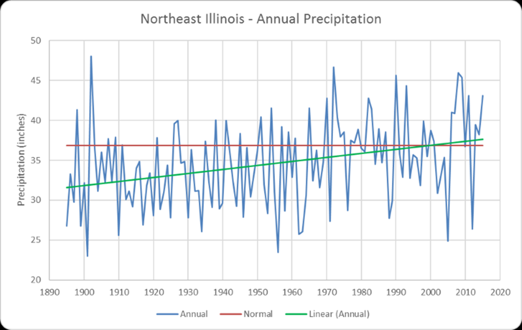
Let me state that again. 125 years of data. A blip on the geologic record. We can estimate that before these past 125 years that it has been colder, warmer, wetter, and drier. This graph shows a great anomaly, the driest year to date was in 1901, and the wettest followed in 1902 (the average was, you guessed it, just about average) – it really makes you wonder what we would learn from the previous decades/centuries/millennia… Some estimates place the age of the earth at 4,543,000,000 years. Our 125 years of data represent 0.00000275% of that length of time. With that data we try to predict an event that has a 1% chance of occurring EVERY year (the “100-year” flood – if our estimates are correct this would have occurred 4.5 million times during the life of the earth). If we were to start our flood analysis period with the Great Flood, Noah’s flood has a 0.03%* chance of recurrence. Fun with numbers.
(* yes, every mathematician will criticize this number as being way too high, and they are correct – but I’m just having fun)
(* yes, my Pastor will criticize me for my age of the earth discussion- but it helps make a point)
(* my Pastor will also note that the chance of a recurrence of the Great Flood is 0.00%- Genesis 9:11)
(* no, I’m not trying to make any secular, religious, political or quasi-scientific point – I’m trying to show that numbers are just numbers, and they can change VERY easily. With any data set there is almost always a way to confirm a pre-conceived point by adjusting the period of the analysis.)
The 100-year flood is not arbitrary, it is our best estimate based upon available data, but it’s just a number that we use as a standard for assessing “reasonable” risk. Not “zero” risk, “reasonable” risk. It’s also NOT a number that WON’T be exceeded. In fact, from a probability analysis standpoint it WILL be exceeded.
Although the average person does not expect to see a 100-year flood during a typical 85-year life, I’ve experienced 3 or 4 in 56 years. In fact, the estimate for the value of the 100-year rainfall in Northeastern Illinois has increased five times in the 33 years that I’ve been an engineer. The latest update was just published last month and is a 12% increase from the previous estimate! Again, it’s not necessarily wetter than “normal”, we just have more data and more data creates a new “normal.” But most of us (except the engineers, hydrologists and mathematicians) would take the chance that we will never see a 1 in 100 (1%) rainfall. Even I used to live by a river (see appendix)– that house no longer exists due to repeated floods (after we moved away), but we accepted the risk of flooding while we lived there because it was a beautiful and fun place to live. Some of our neighbors thought it would never flood. I thought that it was less likely than 1:100. We thought probability was on our side and there was NO chance of a flood THAT big in our lifetimes. We were all wrong. Twice.
But we’ll buy a PowerBall ticket, 1 in 292,201,338 (0.00000034%) chance of winning;
or MegaMillions, 1 in 302,575,350 (0.00000033%).
Now that’s something that we think we have a chance at!
It’s much more likely that I’ll get wet than it is that I’ll get rich.
If you have a specific question, or a topic that you would like learn about, drop me a line at Engineer@HamiltonConsultingEngineers.com. Include “Ask an Engineer” in your subject line. I will respond.
Keep your feet dry!
Howard

Footnote: The offer from my April 12 blog, Do you need floodplain assistance?, still stands. If you need an engineer to look at your property and advise you or your options regarding flood insurance, give me a call or drop me a line. No charge. Review the April 12 blog for more info.
What is a 100-Year Flood?
Appendix – Our First Home
In the late winter / early spring of 1988, Kristen and I were beginning to enjoy some success in our careers as young engineers. Our friends were moving into their first houses and we started discussing the possibility of moving out of our apartment on Michigan Ave. (in Urbana, NOT Chicago). My boss at Daily and Associates in Champaign recommended a realtor, and Kristen and I met with her. She asked us a string of questions:
Realtor “What kind of work do you do?”
H,K “We’re engineers.”
Realtor “BOTH of you!!??”
H,K “Yes”
Realtor “What is your annual salary?”
H “$ X”
Realtor “No Howard, I meant just your salary, not combined.”
H “That is just my salary”
Realtor “!!!! Kristen, how much do you make?”
K “$ XX” (considerably more than me – always has been, always will be)
Realtor “!!!!!!!!!!!!!!!!!!!!!!!!!!!!!”
Realtor “How many bedrooms do you want?”
H,K “3”
Realtor “Rural or urban setting?”
H,K “Rural”
Realtor “Would you like a home in the woods?”
H,K “Yes”
Realtor “Swimming pool?”
H,K “No”
Realtor “On the water?”
H,K “Sure”
Realtor “Boathouse? Dock?”
H,K “Why not?”
Realtor “Tennis courts? Stable? Horses included? Would you like a yacht?”
H,K “Sounds good.”
Realtor “Okay, I have several homes in your price range. Let me make some calls and we can start looking this weekend!”
That night we excitedly called my parents, but heard silence on their end of the line.
Mom spoke first. “Bob, are you going to ask him?”
Dad stammered, “We were hoping that you would move back to Joliet, I really need the help at the office.” Dad seldom spoke and almost never asked for anything, so this was a serious request. We didn’t answer that night, but within a few weeks Kristen had sent some resumes out and had some interviews scheduled. She chose an electronics firm in Sandwich, Illinois about 45 minutes west of the Hamilton Engineering office in Joliet. She would be getting a significant raise in pay, as was I. We were getting excited.
Now all we had to do was find a house that would give neither one of us a commute of over 30 minutes. We drew a circle that went through the east center of Yorkville to the far southeast side of Plainfield. Mom and Dad recommended a realtor. We met with her on a Saturday morning.
Realtor “What kind of work do you do?”
H,K “We’re engineers.”
Realtor “uh huh… What are your annual salaries?”
H “$ XX”
K “$XXX”
Realtor “uh huh…Do you have any other sources of income?”
H,K “No.”
Realtor “Have you considered subsidized housing???”
Our re-introduction to the cost of living in the suburban Chicago area was brutal…but we found a small but perfect house for us – 3 bedrooms, one bath, no basement, outdated everything. But, we could afford it, we had energy to work on updates, it was on the banks of the DuPage River in unincorporated Plainfield Township, and about a 90-minute canoe ride downstream to my brother’s house also on the DuPage River. A few years later my younger sister purchased a home upstream on the East Branch of the DuPage River in Glen Ellyn. In theory, if we started in Glen Ellyn we could visit each house on a weekend-long drunken canoe ride. We never did it, but it was fun to dream about.
Our mortgager required us to by flood insurance. We chose a structure-only policy, with no coverage for contents, for the value of the mortgage only. I grew-up in the area (meaning that I had personal knowledge of 25 years of flood data) and I KNEW that this house would never flood, even though it was in the floodway* of the river. Our neighbor to the north would become our veterinarian. He built his house in the 1960’s and it had never come close to flooding – thus confirming my opinion. I studied topographic maps. Before our house could get a drop of floodwater in it, I-55 would have to be submerged by a foot, which had never happened. I was confident that flood-insurance was just another way for big-government to steal my hard-earned pennies.
In December of 1995 with our third child on the way we decided that it would be nice to have another bathroom and another bedroom. At the end of May 1996, we sold our home on the river and moved to a larger home, on a larger lot, in a fancier subdivision, on a private lake. The couple that bought our home on the river owned the company that had re-roofed it a few years earlier –he had become infatuated with the property while on my roof and had been waiting for the opportunity to buy it. His wife was concerned about flooding, so they purchased the most flood insurance possible. Only six weeks after the closing, in July 1996 they collected on the policy. After a 13-inch rainfall, the DuPage River poured through the house at about a foot deep. I-55 was under water by about 2 feet, so at least I was correct about the relative elevations. The home flooded again a few years later and that property, along with all the neighbors (except two), were sold to the County through a federal buy-out program. Today it is a park with unmarked graves for three dogs and a duck.
So, by the grace of God, I narrowly escaped learning first-hand the value of flood insurance and the accuracy of the flood maps (some of which our firm has updated through site-specific flood studies). For your information I have provided two definitions for you (from FEMA):
* A "Regulatory Floodway" means the channel of a river or other watercourse and the adjacent land areas that must be reserved in order to discharge the base flood without cumulatively increasing the water surface elevation more than a designated height. (I usually add to this definition that this is the part of the floodplain where you see the water flowing quickly during a flood)
Flood hazard areas identified on the Flood Insurance Rate Map (FIRM) are identified as a Special Flood Hazard Area (SFHA). SFHA are defined as the area that will be inundated by the flood event having a 1-percent chance of being equaled or exceeded in any given year. The 1-percent annual chance flood is also referred to as the Base Flood or 100-year flood (also Floodplain or Flood-Fringe Area). SFHAs are labeled as Zone A, Zone AO, Zone AH, Zones A1-A30, Zone AE, Zone A99, Zone AR, Zone AR/AE, Zone AR/AO, Zone AR/A1-A30, Zone AR/A, Zone V, Zone VE, and Zones V1-V30. Moderate flood hazard areas, labeled Zone B or Zone X (shaded) are also shown on the FIRM, and are the areas between the limits of the base flood and the 0.2-percent-annual-chance (or 500-year) flood. The areas of minimal flood hazard, which are the areas outside the SFHA and higher than the elevation of the 0.2-percent-annual-chance flood, are labeled Zone C or Zone X (unshaded). (I usually add to this definition that this is the part of the floodplain where you see the water mostly standing still during a flood).
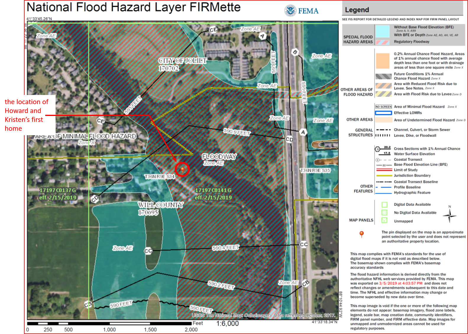
The FIRMette (a portion of the Flood Insurance Rate Map) that includes our former home on the DuPage River, is below. It has not changed much in the last 31 years, but I have. As much as I enjoyed being a river rat, today I would think more than twice before moving into a house that is 18-inches below the base flood elevation.
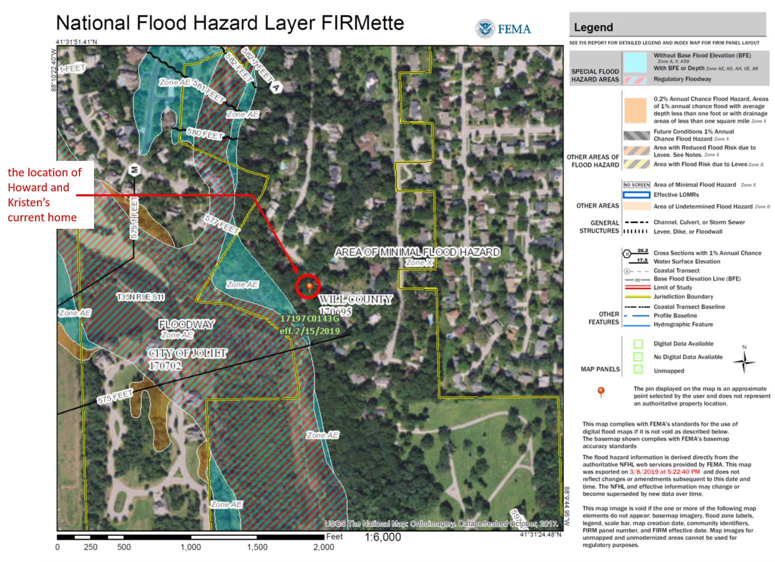
The FIRMette that includes our current home near Rock Run Creek, is below. Although we still enjoy living in nature, with water, our home on the bluff is 13-feet above the base flood elevation. When it rains, I worry about the beavers’ and muskrats’ lodges, not my home.