


READING AND UNDERSTANDING LEGAL DESCRIPTIONS PT II
Friday, December 15, 2017
METES AND BOUNDS DESCRIPTIONS
Gurdon Wattles, in his book WRITING LEGAL DESCRIPTIONS, defines a metes and bounds description as follows: “A series of lines around the perimeter of an area known as a metes and bounds description” “Metes “ meaning bearings and distances and “Bounds” meaning and refers to mounments, both physical and legal. “Legal” meaning some recorded piece of information, either by common law, (sectionalizes land calls) or information recorded in a County Recorder’s Office.
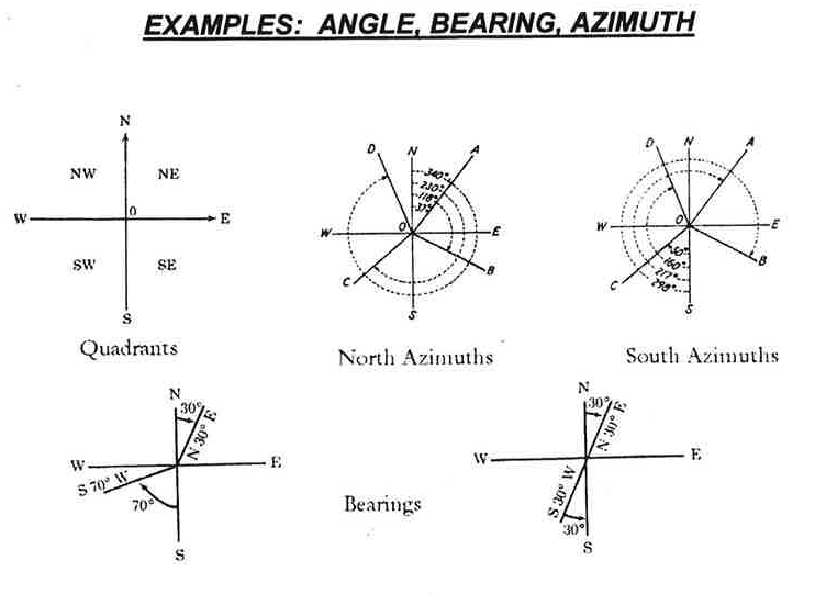
The following example graphically shows how bearings and azimuths work. This is the most common form used in a legal description. Bearings are broken down into four 90 degree quadrants. They are labelled northwest, northeast southeast and southwest. The Northeast and Northwest quadrants bearings are measured from the North direction. The Southeast and Southwest quadrant bearings are measured from the South direction. The Northeast and Southwest quadrant bearings are measured in a clockwise direction. The Northwest and the Southeast quadrant bearings are measured in a counter clockwise direction.
Azimuths can be measured either from a North or South direction. They are both measured in a clockwise direction. The starting point being either directly North or South. The military mainly uses south azimuths for their direction. Very seldom will you see an azimuth used in a legal direction.
You can also use angles described from the proceeding courses in a metes and bounds description, this will be discussed in a later blog.
You must call out a “bounds” of each line if it has one. There are many types of “boundary” calls. Here are a few examples:
- The West Line of Lot 2.
- The West line of Section 30.
- To a point on the east line of a parcel of land deeded to Mr. John Smith by Document Number 123456 in Will County, Illinois.
- To the West Right of Way Line of Main Street.
- To the west line of the Lee R. Koehler Subdivision recorded as Document Number 123456 in DuPage County, Illinois.
Remember if you use a bounds phrase in your description it becomes a qualification of the bearings and/or distances recited before it.
Now let’s look at an example of a typical metes and bounds description. The bearings and distance phrases will be in italics and the bounds calls will be underlined.
There is a graphic example of the metes and bounds description following the description. Can you find any mistakes?
That part of Section 18 in Township 42 North, Range 10 East of the Third Principal Meridian in DuPage County, Illinois, Described as follows: Commencing at the Northwest Corner of the Northwest Quarter of said Section 19; Thence North 90 Degrees 00 Minutes 00 Seconds East on a random bearing system, along the North line of said Section 19, a distance of 2,000.00 feet to a point on the East line of a Parcel of land described in Book 4, Page 11 in the Book of Deeds Recorded as Document Number 9725702 in Will County, Illinois, being also the Point of Beginning: Thence South 00 Degrees 05 Minutes 25 Seconds West along the last said line, a distance of 2644.64 feet to a point on the North line of the said Southwest Quarter of said Section 19; Thence South 89 Degrees 50 Minutes 34 Seconds West along the North line of the Southwest Quarter of said Section 19, a distance of 100.27 feet to the Northwest corner of the Smith Subdivision being a subdivision of part of the Southwest Quarter of Section 19, Township 42 North, Range 10 East of the Third Principal Meridian, Recorded as Document Number 97536210 in DuPage County, Illinois; Thence southerly along the West line of said Smith Subdivision for the following three courses: (1) Thence South 0 Degrees 0 Minutes 00 Seconds West, a distance of 500.00 feet to a Point of Curvature; (2) Thence southerly along a curve concave easterly and having a radius of 500.00 feet, an arc length of 300.00 feet to a Point of Reverse Curvature; (3) Thence southerly along a curve concave westerly and having a Radius of 300.00 feet, an arc length of 500.00 feet to a point on a non-tangent line; Thence South 00 Degrees 01 Minutes 21 Seconds East, a distance of 1,518.45 feet to a point on the South line of the Southwest Quarter of said Section 19;
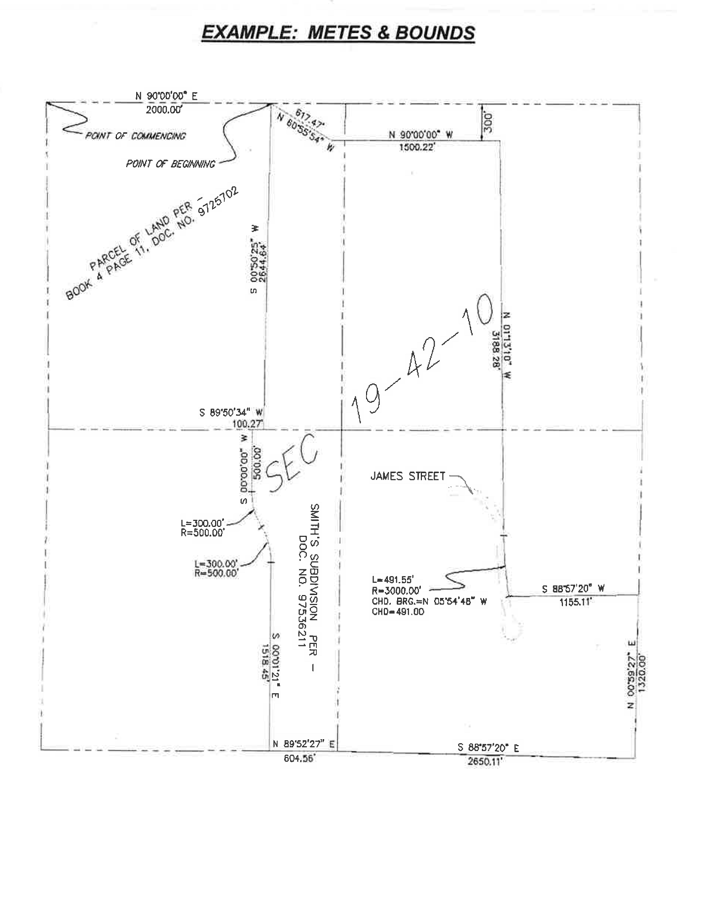
This is only half of the legal description shown on the graphic example, can you finish the legal? Can you find the 5 mistakes?
For the remainder of the legal and answer to how many mistakes I made please e-mail me at lkoehler@REHamilton.org. I will wait till I get a few answers and send you the remainder of the legal and answers.

Lee Koehler is Chief Professional Land Surveyor for Hamilton Consulting Engineers.